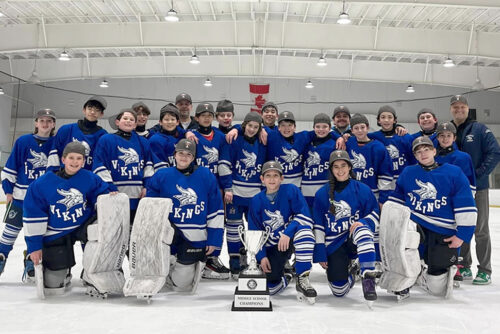
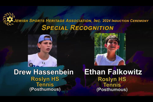
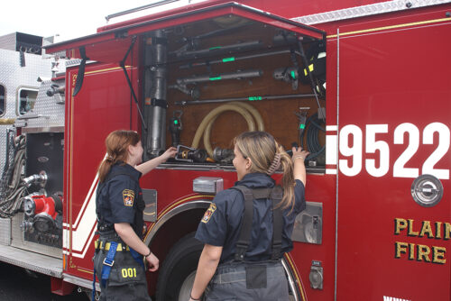
Farmingdale Observer Floral Park Dispatch Garden City Life Glen Cove Record Pilot Great Neck Record Hicksville Illustrated News Levittown Tribune Manhasset Press Massapequan Observer Mineola American New Hyde Park Illustrated News Oyster Bay Enterprise Pilot Plainview Herald Port Washington News Roslyn News Syosset Jericho Tribune Three Village Times Westbury Times Boulevard Magazine Features Calendar Search Add An Event Classified Contacting Anton News

LongIsland.com Logo An Official Newspaper of the
LongIsland.Com Internet Community

News Sports Opinion Obituaries Contents
News

Loretta Dionisio is a hydrogeologist with the Nassau County Department of Public Works and a team member of the Nassau County Groundwater Guardian Community.

Water, our most precious resource, is all around us here on Long Island. The surrounding saltwater bodies provide abundant opportunities for fishing and boating, while the freshwater lakes, streams and ponds lend a serene beauty to our recreational areas.

However, as we all know, unlike the boroughs of neighboring New York City, we do not derive our drinking water from surficial water bodies, but rather from a vast groundwater system beneath our feet. The groundwater system consists primarily of several "aquifers" ¬ saturated sand and gravel deposits ¬ separated by clay layers. These aquifers, termed the Lloyd, Magothy, and Upper Glacial aquifers, are fed "or recharged" by rainwater and snowmelt, as are our streams, lakes and ponds. Due to extensive development of the island over the past 50 or so years, the groundwater system is also subject to contamination from above.

Nassau County is underlain by crystalline bedrock which is non-water bearing. The depth to bedrock varies from 200 feet in the northwest portion of the county, to as much as 1800 feet in the area of Tobay Beach in the southeast. Lying atop the bedrock are deposits dating back to the Cretaceous age (65 million years ago). The deepest of these is the Lloyd Sand member of the Raritan formation.

The Lloyd is a water-bearing formation comprised primarily of sand with some clay, gravel, and silt and averages between 60 and 400 feet thick. Access to the Lloyd for water supply purposes is restricted due to the low amount of recharge water reaching the Lloyd. Above the Lloyd lies the Raritan Clay. The Raritan Clay consists largely of clay and silt, with sandy beds common, and therefore yields little water. The clay ranges from 50 to 250 feet thick, and strongly inhibits the flow of water into and out of the Lloyd aquifer.

The thickest and most water productive formation is the Magothy. Consisting of fine to coarse sand with some clay lenses, the Magothy is anywhere from 100 to 1200 feet thick, and is responsible for providing about 80 percent of Nassau County's drinking water. Above the Magothy aquifer are glacial deposits, averaging in thickness from 300 to 400 feet. The "Upper Glacial" aquifer, as it is termed, is typical of glacial outwash as it is a mixed bag of stratified gravel, sand, silt and clay.

The Upper Glacial aquifer and many surficial features we see today are the result of the glaciers that extended south of the Connecticut coastline, transporting and crushing massive boulders and other rocks as they progressed. As the glaciers receded and melted, they left behind the detritus they carried from afar, gradually depositing the materials layer by layer, year after year.

The leading edge of the glaciers' advance is usually characterized by heavier "moraine" material which is the first to be deposited when the glacier begins to recede. The boulders and hillier terrain roughly north of the Long Island Expressway fall into this category. In fact, many of our lakes and ponds north of the LIE were formed when enormous blocks of ice broke away from the departing glacier. When the ice melted, the water filled the remaining depression. Lake Success in Nassau and Lake Ronkonkoma in Suffolk County were formed in this fashion. Lake Ronkonkoma is so deep it was once thought to be connected to Connecticut, a fanciful but impossible concept. Land features south of the LIE are distinctively "outwash plain" in origin, where glacial runoff carried finer sediments toward the ocean.

These ancient deposits have been circulating water for millennia. For each rainfall since the formation of the island, there is percolation through the glacial deposits down into the deeper aquifers, and overland runoff into surrounding surface water features.

The roughly 44 inches of rain which falls annually in Nassau County translates to about 660 million gallons of water being applied to its land surface every day. Of this, about half is either used by plants, evaporated from the land's surface or flows into the surrounding streams, bays and ponds. The remaining 330 million gallons per day percolates down through the glacial deposits to eventually recharge our groundwater system. Once there, the water is either withdrawn for consumption by the hundreds of water supply wells dotting the island, or it discharges as streamflow and underflow to the surrounding bays and to the ocean. This the water has done, and will do, for time immemorial.

Although the configuration of where the water goes and the amount of water circulated varies with withdrawal and recharge patterns, this natural process will always persist. Unfortunately, water is not the only substance that can percolate through the soil layers and circulate through our groundwater system. Contaminants can find their way in, as well.

Prior to the development of Nassau County, the deep recharge area - that area of land surface that contributes recharge to the deeper portions of the aquifer system ¬ ran roughly west to east through the center of the county, along where the LIE now resides. The balance of the land surface recharged the Upper Glacial aquifer and fed the lakes and streams.

Here on Long Island, the LIE basically represents the groundwater divide. In a natural system, a groundwater divide is a region across which there is no flow. Rainwater landing right on the divide, theoretically, has a flow path which takes it straight down to the deeper depths of the aquifer system. Rainwater falling to one side of the divide, for example, to the north of the LIE, will only flow north once it encounters the saturated material below. It cannot cross the "divide" and flow southward under natural conditions. Likewise, water landing on the south side of the LIE cannot flow northward. Nearer the shoreline, away from the center of the county, the water landing on the surface generally recharged the shallow aquifer system or discharged to streams and lakes. The natural flow patterns are disrupted, however, when large amounts of water are withdrawn from the groundwater system.

With development of Nassau County came increased water demand, to the extent that today, on average, about 180 million gallons of water per day are withdrawn from the aquifer system, primarily from the Magothy aquifer. This radically changes the natural flow patterns.

Due to extensive pumping from the Magothy aquifer, much of the water that would ordinarily reach the Lloyd aquifer is intercepted and pumped from public supply wells in the Magothy instead. In addition, a good deal of the water that previously would have circulated through the Upper Glacial aquifer is now pulled down by the wells pumping in the Magothy. Thus, the majority of the land surface of Nassau County now recharges the Magothy aquifer, with only small areas near the center recharging the Lloyd and some coastal areas contributing to the Upper Glacial aquifer.

As stated previously, rainwater is not the only thing that can percolate through the soil layers and down into our water supply. Naturally, having 1.3 million people in Nassau County alone living directly over their sole source of drinking water has got to have some detrimental effect on the quality of that water.

It is critical for each and every one of us to realize that anything applied to the ground ¬ be it pesticides, fertilizers, automobile fluids, or degreasers ¬ to name a few, could potentially find its way into and impact our water supply. Just a teaspoon of motor oil can contaminate thousands of gallons of water. It is up to each individual to do their part not to waste water and to think twice before disposing of hazardous materials. Judicious use of home gardening and automotive products and the sensible disposal of same can go a long way in protecting our most precious resource - our pure and plentiful, yet vulnerable - groundwater supply.


| antonnews.com home | Email the Three Village Times |
Copyright ©1998 Anton Community Newspapers, Inc.
All Rights Reserved.
LinkExchange
LinkExchange Member